This is Weather Why, a series of articles exploring frequently asked questions about weather and explaining major local and national weather phenomena.
Worldwide attention has recently been focused on the destructive wildfires across Southern California, but how do these fires form? Why is Southern California so highly susceptible to such devastating fires in one of the most populous regions in the United States?

Smoke is seen from NASA's Aqua Satellite coming from wildfires, January 7th, 2025. Credit: NASA
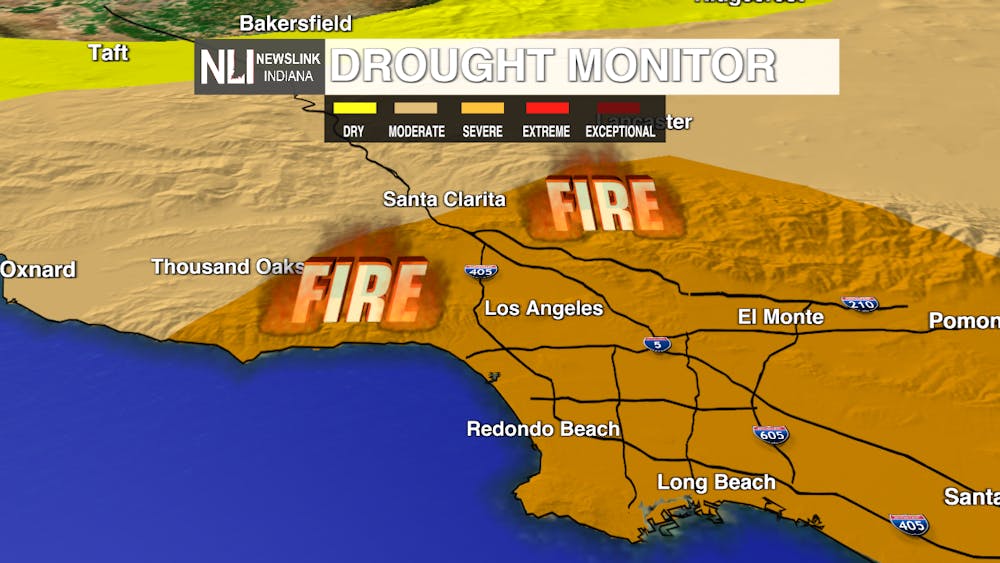
In many cases, climatic conditions and wind patterns are often to blame. Significant drought has plagued portions of California for years, creating extremely dry conditions in the low chaparral, grassland and trees in the San Gabriel and Santa Monica mountains that overlook much of metropolitan Los Angeles and the surrounding areas of the Palisades region. On Mount Wilson, one of the highest points in the San Gabriel mountains, rainfall during the dry season between June and September averages less than half an inch during those months. While these months are typically of most concern for fires, the fire season has grown longer each year as drought persists and warmer conditions linger much further into the fall and winter months.

Drought monitor showing severe drought conditions extending over nearly the entirety of Southern California.
Human activity exacerbates these conditions when urban areas are put into place, often at the expense of forests and grasses. Improperly extinguished campfires, gasoline tanks and oil, as well as lit cigarettes that have been tossed from moving vehicles all can start fires. Infrastructure can also play a part in causing fires, as sparks from power lines have previously been responsible for some of the costliest fires in the state’s history.
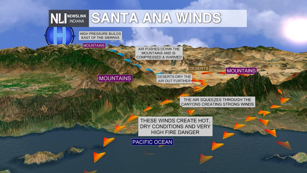
When many of these fires start, they typically are small and insignificant. However, they can quickly be amplified and burn wildly out of control by a unique form of geography and topography that creates strong winds known as Santa Ana winds. These winds result from high pressure areas in the inland desert of California and the Mojave Desert, moving warm and typically very strong dust-covered winds down the hills and mountain sides of Southern California. These winds can move incredibly fast as they quickly descend, oftentimes in excess of 75+ mph, picking up embers and tossing them down into wooded or populated areas in the span of minutes.

These Santa Ana wind events are quite common, occurring anywhere from 10-20 times a year, but when combined with significant drought and human interaction, a perfect storm of wildfires can lead to disastrous fires across the region.
- Chief Weather Forecaster Noah Gordon
Follow us on Twitter @NLIWeather for breaking weather updates.
NewsLink Indiana is a proud Ambassador for the NOAA Weather-Ready Nation program.
For more information about the Weather-Ready Nation program please click HERE


