
The National Weather Service has confirmed three tornadoes from last night's storms in Delaware and Jay counties. According to the NWS, storms formed along a boundary to the west of our viewing area that allowed them to spin up brief tornadoes that were momentarily detected on radar. While several special weather statements were issued for Delaware and Jay counties, no watches or warnings were in effect at the time. NewsLink Indiana has confirmed damage in both Portland and Yorktown. There have been no reports of injuries associated with these storms.

Photo credits: Peyton Davis
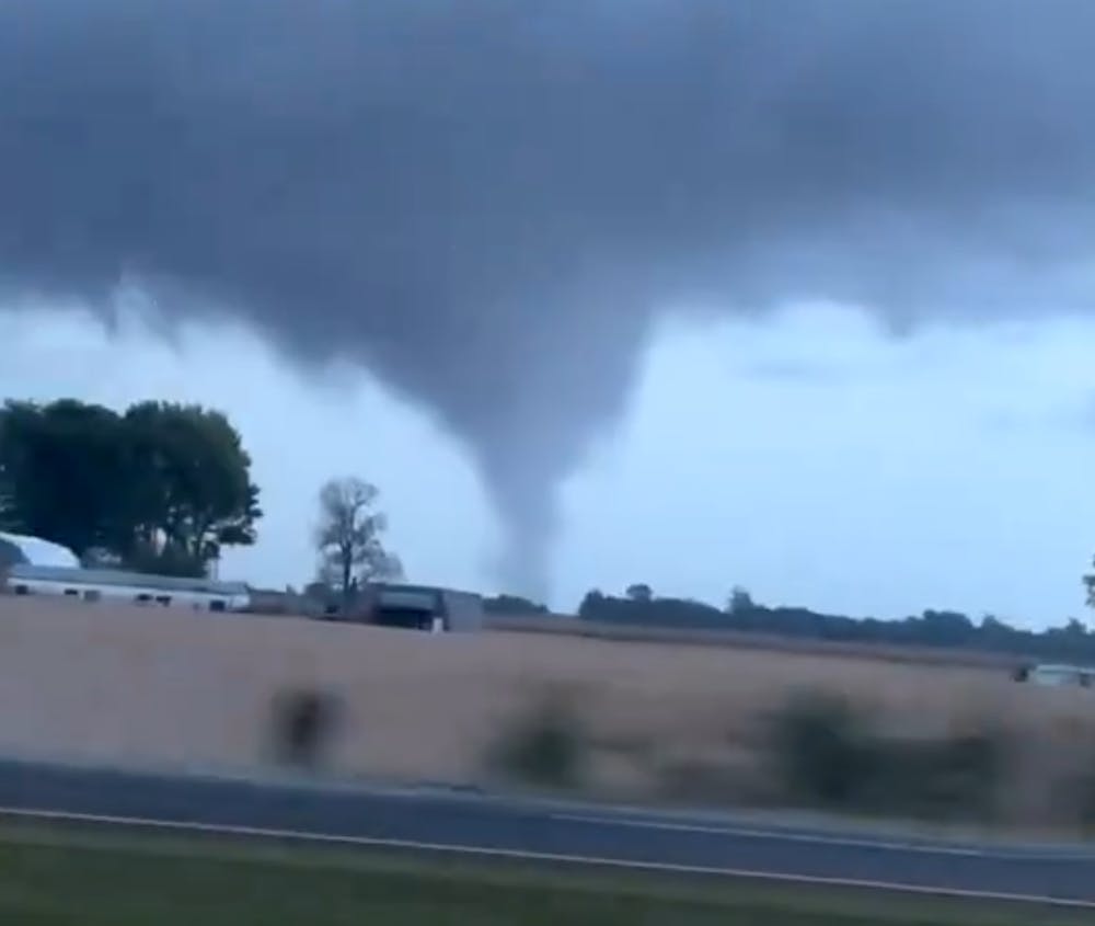
Yorktown Tornado declared EF-0
Video Provided: Brandt Applegate
According to the Delaware County EMA: "This evening around 7:30pm, public safety personnel reported what appeared to be a funnel cloud in western Delaware County, north of Yorktown in the Cammack area. In an abundance of caution, Delaware County EMA set off the outdoor warning sirens. It is a rare occurrence that we set off the sirens without a National Weather Service Warning. EMA Staff surveyed reported damage in the Cammack area, and verified significant roof and partial structural damage to a large commercial structure. There has also been reported damage in the Portland area in Jay County from the same storm. We will be working with the National Weather Service to determine the type and strength of the storm."
As of this morning, the National Weather Service in Indianapolis has confirmed that a small shower produced a brief landspout tornado to the west of Muncie in Delaware County on the evening of September 22. It appeared that the cell developed along a weak boundary extending to the west from where the landspout tornado occurred. A landspout is a tornado that does not arise from organized storm scale rotation and therefore is not associated with a wall cloud visually or a mesocyclone on radar. Landspouts often begin close to the ground and develop upwards.
NewsLink Indiana was also able to confirm damages to TK Constructors in Yorktown. NewsLink Indiana was able to visually confirm damage to the business Sunday night. The National Weather Service said in a summary that the business sustained damage to portions of the west side of the building with the wall collapsed inwards. No other damage was found to adjacent properties.

Photo credits: Jake Dickman & Gavin Smith
Portland sustains damage after two tornadoes touch down
NewsLink Indiana also confirmed Sunday night reports of heavy damage within the Portland city limits as well as confirmed damage to the roof of Jay County High School and other structures along IN-67. Several houses were confirmed to have roof and siding damage, with severe tree limb damage reported as well along the storm's path.

Photo credits: Peyton Davis
NewsLink Indiana was also able to confirm damages to TK Constructors in Yorktown.
Monday afternoon, the National Weather Service in Northern Indiana confirmed two tornadoes associated with a low-topped supercell thunderstorm. While the first of these tornadoes was rated an EFU as it moved across open farmland, the storm quickly produced a second, stronger tornado that was rated EF1 with maximum sustained winds of 110mph, tracking over 2 miles, producing damage to several structures along the southwestern side of the city of Portland, including Jay County High School. As a result of damages to the school, Jay County Schools have announced that the high school will switch to eLearning Tuesday and then Remote Learning Wednesday through Friday as critical infrastructure at the school, such as HVAC, is repaired. Damage was also reported at the American Legion building on W Walnut Street in Portland.
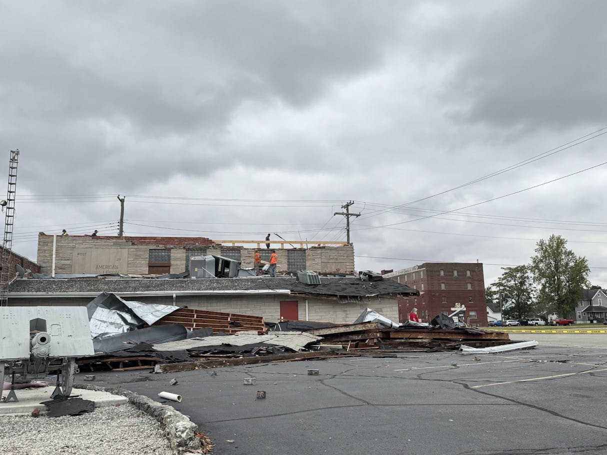
Photo credits: Peyton Davis
Why was there so little warning with these tornadoes?
Due to these storms forming in an already unfavorable environment on a day where no severe storms were expected, forecasters had not issued any watches or warnings. An atmospheric boundary to our west was able to amplify and allow several non-severe storms to rotate, resulting in several spin-up tornadoes. Since rotation on radar was incredibly minimal and very rapid, storms did not meet the criteria for a severe thunderstorm or tornado warning. However, several special weather statements were issued for the possibility of landspout tornadoes.
This story will be updated as information becomes available.
For comments, contact editor@bsudailynews.com
Read More
IPR: Muncie commission approves money to begin demolishing part of Muncie Mall
By Indiana Public Radio / 17 hours agoThe Muncie Redevelopment Commission will spend tax dollars earmarked for the Muncie Mall to demolish part of the mall complex.

“Every Muncie neighbor is important:” Vigil honors deported community member
By Trinity Rea / YesterdayDozens gathered for prayer, reflection and community support after a Muncie man was deported by ICE.

Former Ball State Mens Tennis member Gene Orlando set to coach team
By Staff Reports / 2 days agoFormer Ball State Men's Tennis Hall of Famer Gene Orlando has been named the new head coach of the team, according to Ball State Athletics, following the departure of long-time Head Coach Bill Richards, announced last week.
