
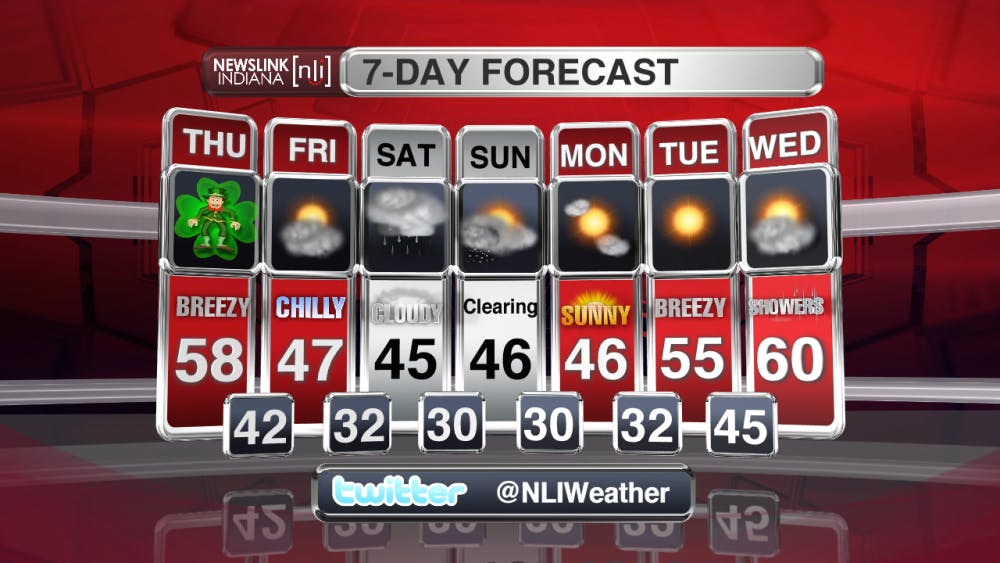
As the breezy conditions start to wind down over night, winds will stay pretty consistent through tomorrow from the WSW. This will allow temperatures to stay above average, hitting a high tomorrow of 58 degrees. We should see clear skies for your Thursday. As we go into Friday however, a shift to a more northerly flow of winds will drastically drop temps into the upper 40s. Look for more cloud on Friday giving way to some showers and possibly a mixed precipitation for Saturday night into Sunday morning. Highs for the weekend will reach into the mid to upper 40s. The beginning part of your work week next week look clear with increasing temperatures into Tuesday.
Read More

Ball State’s student chapter of the American String Teachers Association traveled to the national conference to accept the Outstanding Student Chapter Award
By Sean Behling / 16 hours agoThe chapter traveled to a national conference, March 19-22, to receive the award.

Ball State Professor Nicole Etcheson’s book has been adapted into a documentary film
By Gracie Parkhurst / YesterdayNicole Etcheson’s 350-page book, “A Generation at War: The Civil War Era,” covers the lasting effects of the U.S. Civil War on life in Putnam County, Indiana.

Anti-Trump protest held along the Wheeling Avenue and McGalliard Road intersection
By Hannah Amos / 2 days agoMuncie community members participate in a nationwide protest along Wheeling Avenue and McGalliard Road intersection holding signs and chanting against the Trump administration.
